Discover Yaxchilán
Yaxchilan (yax-chee-LAN), which means “Place of Green Stones” in Mayan, is a place of wondrous temples, plazas and story-telling carvings and sculptures. Poised on the banks of Rio Usumancinta in Chiapas (bordering neighboring Guatemala), this imposing compound has been swallowed by its jungle surrounding—ceiba and gum trees are home to chatty howler monkeys and toucans. Yaxchilan is where nature and man meet in inspiring harmony.
When visiting spectacular Yaxchilan, you really feel like you’ve stepped back in time. It is the only well-trodden archaeological center in Mexico that cannot be reached by car or bus: you have to take a boat trip from Frontera Corozal—a small town on the banks of Rio Usumacinta (the river that divides Mexico from Guatemala) or much less commonly, fly in from nearby Palenque or Ocosingo landing on the nearby airstrip. The boat trip is the best bet—more exciting and less expensive, too.
During its hey-day (the Late Classical period of 800 to 1000 AD), Yaxchilan developed into a very powerful and influential urban and trade center on the banks of the Usumacinta River. Over 120 structures made up this city, grouped into 3 main areas: the Great Plaza, the Grand Acropolis and the Small Acropolis
The site is best known structurally for its detailed facades and large ornamented roof combs and its lintels, unusually carved on BOTH sides.
Yaxchilan is within a comfortable driving distance from other popular archaeological sites in Chiapas: it makes a convenient side-trip from Bonampak archaeological site as it’s just 31 miles (50km) northeast there. Palenque is about 118 miles (190km) from Yaxchilan and many visitors to Yaxchilan also take advantage of being the area to visit these two other important archaeological sites.
Key Attractions
As you disembark at the site’s pier, you walk up a ramp and into the jungle that stops short on the bank of the river. The entrance to the site takes you through a tunnel under Edificio 19 (Edifice 19), and you break out into the north west corner of the Grand Plaza—an open space overlooking an ancient plaza, surrounded by structures in varying conditions.
On the left as you look across the Plaza from Edificio 19 are a couple of buildings—making up Edificio 17, apparently used in ancient times as a sauna.
A number of Steles (stone blocks) are dotted all over this site as in nearby Bonampak; some of them are carved on both sides and you can see an example of one of these in Edificio 20. These Steles have helped archaeologists to piece together much of the history of the site as their paintings and hieroglyphic inscriptions reveal a lot of information about the life and times of the ancient Maya people who inhabited these lands.
Visit the Steles in the Grand Plaza and continue towards Edificios 5, 8 and 20 on the southwest side of the site; double back to Stele 1, where on the left you’ll see an ancient stairway rising up to a building on the brow of the hill.
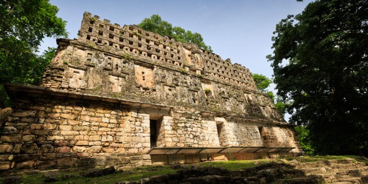
The best preserved building in Yaxchilan is Edificio 33, which you have to climb up to see properly and enjoy; there is an ancient stairway to it that rises up from Stele 1. This is the building featured as the main picture of our guide.
There’s a trail that leads behind this building and Edificio 30, and then downhill to the Small Acropolis and Edificios 42,44 & 51; alongside these you’ll also witness some unusual tree formations, where several trees have grown into one!
If you keep walking downhill from here, you’ll end up back on the main trail that led you into the site, beyond the original Edificio 19 that you walked through to arrive on the edge of the Grand Plaza and your tour of Yaxchilan will be complete.
Getting There & Around
By Air: The closest airport to Yaxchilan is Villahermosa and Tuxtla Gutierrez. For detailed information about flights and flying, see the Mexperience guide to Air Travel in Mexico.
By Bus: Although there are some local buses traversing the route from Palenque to Frontera Corozal (the small town where the boats embark), we strongly recommend you take an organized tour or drive here in a car; also see the warnings about traveling after dark. For detailed information about bus transportation read the Mexperience guide to Bus Travel in Mexico.
By Car: You need to travel to Frontera Corozal on Highway 198 and park your car in town. The town is on the edge of the river Usumacinta, that marks the political divide between Mexico and Guatemala. Also see additional information about Driving in Mexico and Mexico’s Toll Roads on Mexperience.
Boat Ride: To reach Yaxchilan, you must take a boat ride from Frontera Corozal. Frontera Corozal is also an eco-center; there’s a good restaurant here where you can eat and drink well and you can also rent rooms for the night in what is an upscale hostel—ask locally for details. If you arrive here by organized tour (see Practical information, below), everything will be taken care of, otherwise you will need to arrange to hire a boat, and you’ll need to negotiate your arrangements in Spanish. The price is the same for however many people travel in the boat, with a modest surcharge for groups over 5 people with up to a maximum of 10 people per boat; if you are traveling in small numbers, it may well be worthwhile finding another small group and sharing the cost. The boat trip is pleasant and takes around 45 minutes each way. You will see plenty of wildlife and may catch a glimpse and sound of the famous howling monkeys that live here. You might even see the odd crocodile or two.
Yaxchilan Pier: Yaxchilan has a small pier where visitors disembark and re embark on the way back to Frontera Corozal.
Best Visited by Organized Tour: Yaxchilan is close to Bonampak and Palenque, and tours offer the opportunity for visitors to travel from Palenque to Yaxchilan via nearby Bonampak as part of a day trip to these sites. Bonampak and Yaxchilan are situated along the frontier highway with Guatemala, Highway 307. Highway 307 must NOT be traveled on after dark. Tours begin early in the morning and return to Palenque by dusk; if you are traveling independently be sure you follow the same schedule. See Yaxchilan Essentials, below for more details and links to tours.
Yaxchilán Essentials
Opening Days & Times: 7 Days a week; 8 am to 5 pm. Modest admission charges apply and there are concessions for students, children and seniors. On Sundays, admission is free for Mexican citizens and foreign residents (with proof of residency).
Local Tours: Due to their remote locations, Yaxchilan and Bonampak are best visited as part of an organized tour. Tours and activities are organized and run by well-established, professional and fully-insured operators who can help you to get the most from a visit to these archaeological sites. Contact Mexperience to arrange your customized tour of the area
Photography & Video: A permit is required if you want to use a tripod to take photographs at the archaeological site. A small fee is made for the use of hand-held video equipment. Read the section on Mexperience Mexico Essentials about Video & Photography at archaeological sites in Mexico.
Ideal Clothing & Footwear: You’ll need a good, comfortable pair of walking shoes with a non-slip sole – Yaxchilan is an extensive archaeological site. Wear light clothes, carry plenty of water and wear a sunhat – it gets very hot and humid here. Insect repellent is essential as this site is located in the jungle. See Local Climate, below.
Travel Insurance: We recommend that you are adequately covered with travel medical insurance and/or travel assistance insurance when you are visiting Mexico. Read the Mexperience guide to Travel Insurance in Mexico for full details and links to specialist insurance suppliers.
Driving in Chiapas – Safety Advice
If you are driving independently in this region, using a rental car or your own vehicle, its important that you heed some special advice.
It’s best to keep off all highways after dark, unless you know them well and have good local knowledge.
The highway from San Cristobal to Palenque (Highway 199) must NOT be traveled on after dark. It is generally regarded as safe during daylight hours. This road cuts through some extremely remote territory, including in the latter stages, sweltering jungle.
The above also applies to Highway 307 between Palenque and Bonampak / Yaxchilan archaeology sites. Most travelers join others and see these places as part of an organized tour, but there are advantages to driving yourself, and if you do, you must take these additional precautions for your safety.
Military Checkpoints: Expect to pass through at least one, but probably several of these on your road trips through Chiapas. Don’t be alarmed, the soldiers may or may not check your car’s trunk; they are polite, respectful and can even provide local advice and directions if you need them.
See Also: Military Checkpoints in Mexico
Nearby Places & Attractions
Major Cities: Mexico City (Closest)
Colonial Cities: Comitan, Tuxtla Gutierrez, San Cristobal de las Casas, Villahermosa, Oaxaca
Nearest Beaches/ Resorts: Cancun, Cozumel, Playa del Carmen, Isla Mujeres
Other Archaeological Sites Nearby: Palenque, Tenam Puente, Bonampak, Chinkultic
Local Climate
The local climate is the same as that for Palenque, which is jungle weather: extremely hot and humid. Dress with light clothes that enable your skin to breathe. Bring sun screen, insect repellent and a hat. Carry plenty of water and stay well hydrated at all times.
Weather & Climates in Mexico
Learn more about the weather and climates through the seasons and regions by connecting to the Mexperience guide about Weather and Climates in Mexico
Mexico in your inbox
Our free newsletter about Mexico brings you a monthly round-up of recently published stories and opportunities, as well as gems from our archives.